Riisitunturi's snow trees: a guide to the tykky forest
What are the snow trees at Riisitunturi and when can you see them?
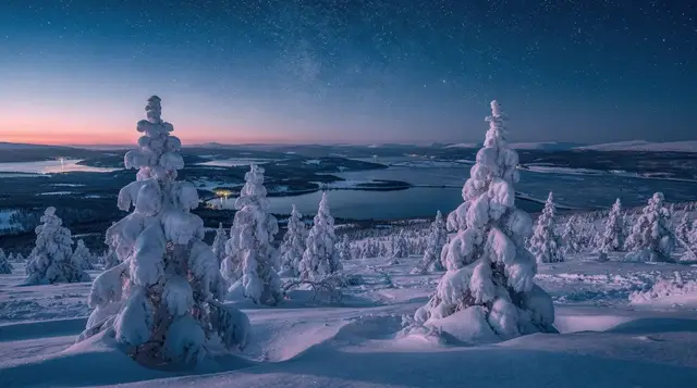
They are spruce trees bent under thick layers of wind-packed snow and rime frost, called tykky, found on the fells of Riisitunturi National Park. The effect builds through the winter and is usually at its heaviest from January to March, but it depends on that winter's weather, not a fixed date.
The fell where trees disappear under snow
Riisitunturi National Park sits about 170km east of Rovaniemi, past Posio, on a low chain of fells that catch damp air rolling in from the east. What makes the park worth the drive is a specific weather effect: spruce trees on the exposed slopes get plastered, week after week, in layers of wind-driven snow and freezing rime, until some of them are buried into rounded white mounds that no longer look like trees at all. Finns call this tykky. Visitors usually call it “snow monsters,” borrowing the term used for the same phenomenon in northern Japan.
This page covers Riisitunturi specifically: how the tykky forms, when it’s actually there, what the hike involves, and how to get to a fell that has no train station, no bus stop, and only one realistic road in. It doesn’t cover Korouoma canyon or the Karhunkierros trail — both are nearby, both have their own dedicated pages, and neither is the same hike.
What tykky actually is, and why Riisitunturi has so much of it
Tykky forms when moist air meets freezing temperatures repeatedly over weeks, depositing snow and rime frost onto branches faster than it falls off. It happens in a band of fells across northeastern Finland, but Riisitunturi is unusually good at producing it because of where it sits: low fells, around 250 to 330m, directly in the path of damp air pushing in from Russian Karelia and the White Sea before it dries out further west. The trees on the exposed western and southern slopes take the brunt of it.
The effect builds cumulatively. Early in the season the trees just look snow-dusted. By deep winter, if conditions have cooperated, some spruces are entirely swallowed — a solid white shape with no visible branch or needle, standing shoulder to shoulder with dozens of others across the open fell side. Photographers describe the field of shapes as looking like a crowd, or a flock of something, frozen mid-movement. It photographs best in flat overcast light, when there’s no harsh shadow splitting the white shapes apart, and worst in bright sun, when the glare flattens the texture.
None of this happens on a fixed schedule. It’s driven by that particular winter’s temperature and moisture pattern, not the calendar, and this is the single most important thing to understand before planning a trip around it.
When to go — and why nobody can promise you a date
January to March is the general window, with the heaviest tykky typically reported in February, once several weeks of accumulation have had time to build. That’s a pattern, not a guarantee. A dry cold snap early in the season, or a warm spell that melts and refreezes the load, can leave the trees thinner than photos from a good year suggest. Conversely, an early cold, wet November can get the tykky forming ahead of the usual curve.
The trap to avoid is booking a specific week months out on the assumption that “February” means the trees will look exactly like the postcard. They usually do, in most winters, but treat it as a strong likelihood rather than a fact you can plan a single non-refundable day around. If your dates are flexible, ask a local operator or the park’s visitor information for a read on the current season before committing the full day the drive requires. If you’re going with a guided tour, the guides are out there weekly and know exactly how the fell looks that month — that’s one of the real advantages of not going it alone.
By April, the accumulated snow starts collapsing under its own weight and warmer daytime temperatures, and the effect thins out fast. Outside the January–March core, expect a lighter, patchier version of the phenomenon rather than none at all — Riisitunturi’s slopes hold snow well into spring most years.
Getting there from Rovaniemi
It’s roughly 170km, about 2 hours 30 minutes to 2 hours 45 by car, heading east through Posio on Route 81 then smaller roads into the park. The roads are paved and maintained but unlit for long stretches once you’re past the towns, and reindeer cross without warning — see the driving in Lapland guide before you go if you haven’t driven Finnish winter roads before. Winter tyres are mandatory on any rental in this season regardless.
There is no practical public transport option that gets you to the Kuntivaara trailhead and back within a day — this is a self-drive or guided-tour destination, not a bus one. A guided day trip removes the driving risk entirely, includes a guide who knows the current trail and snow conditions, and usually bundles in food; several options are listed below.
If you’re combining Riisitunturi with other stops in the area, Kemijärvi and Salla both sit on plausible loop routes, and Pyhä-Luosto National Park — with its own fells and the Luosto amethyst mine — is close enough to fold into a longer eastern Lapland itinerary rather than a single day.
The hike itself
The main route starts from the Kuntivaara car park and climbs onto the fell to the tykky viewpoint and back, a loop of around 5 to 6km. Budget 3 to 4 hours including stops for photos, more if the snow is deep and unpacked. The climb itself takes roughly an hour at a steady pace; the trail is marked but not lit, and by afternoon in midwinter you’ll likely finish in fading light or after dark, so a headtorch is worth carrying even on a guided trip.
Underfoot conditions vary through the season. Early and mid-winter, expect packed snow with duckboards buried under it in places; poles help with balance more than the incline demands. There’s no way to drive up to the viewpoint — the car park sits at the base, and every visitor, guided or independent, walks the same climb.
| Detail | What to expect |
|---|---|
| Distance | ~5–6km round trip from Kuntivaara car park |
| Time | 3–4 hours including stops |
| Terrain | Packed snow trail, one significant climb (~1 hour up) |
| Elevation | Fell tops around 250–330m |
| Facilities | Basic; no café or shop at the trailhead |
| Difficulty | Moderate — fitness needed, no technical skill |
There’s no café, shop, or heated shelter at the trailhead — bring your own hot drink and food, or go with a tour that includes a campfire stop or barbecue, which several of the operators below do.
Guided or self-drive
A guided tour solves three problems at once: the two-and-a-half-hour winter drive each way, not knowing whether the current tykky is worth the trip, and standing at a viewpoint in January without a hot drink. Several operators run the route as a day trip from Rovaniemi.
a full-day wilderness hike to the tykky trees with a campfire barbecue included is the most straightforward option built specifically around this hike. For a longer combined day that packages transport with the park visit, a guided day trip from Rovaniemi covering the national park handles the drive and the walk together.
Photographers who want more time at the viewpoint and fewer people in frame should look at a private snow-monsters photography tour with a campfire barbecue, which moves at a slower, shooting-focused pace. There’s also a lower-key option for a shorter visit: a Riisitunturi day trip with a stop for local pizza on the way, useful if you want the fell without committing to a full hiking day.
Driving yourself costs less and lets you set your own pace, but means covering the ~340km round trip in winter road conditions and reading the current snow situation without local knowledge. If you’re comfortable with Finnish winter driving and have checked the three-layer clothing system is sorted, it’s a reasonable choice; if this is your first Lapland winter, the guided options remove most of the risk.
What to wear
This is a moving-then-standing-still hike in temperatures that are commonly -10 to -25°C on the fell, sometimes with wind exposure once you clear the treeline. The climb will warm you up; the viewpoint, where you’ll want to linger for photos, will cool you down fast. Base layer in wool or synthetic, an insulating mid layer, and a windproof, snow-shedding outer shell, with the mid layer easy to add or remove as you move.
Proper winter boots with real tread — the descent on packed snow is where people slip, not the climb. Guided tours generally don’t supply outdoor clothing for this hike the way a snowmobile or husky tour does, since you’re expected to arrive already dressed for a winter walk; check with the specific operator if you’re relying on rented kit.
Riisitunturi versus its neighbours
It’s easy to blur Riisitunturi together with the other frozen-landscape spots east of Rovaniemi, since they’re all reached via similar roads through Posio and share a general region. They’re not the same trip.
| Park | Distance from Rovaniemi | What it’s known for |
|---|---|---|
| Riisitunturi | ~170km | Tykky snow trees on fell slopes |
| Korouoma Canyon | ~140km | Frozen waterfalls in a 30km gorge |
| Oulanka / Karhunkierros | ~190–220km | Long-distance trail, Kiutaköngäs rapids |
| Pyhä-Luosto | ~120km | Two fells, amethyst mine, ski resort |
If a single day trip is trying to cover Riisitunturi and Korouoma together, check the actual driving distance between the two trailheads before assuming it’s an easy add-on — it’s a further stretch of road, not a five-minute detour, and doing both properly in one day is tight. The Korouoma frozen waterfalls guide covers that hike on its own terms.
Combining it with the rest of your trip
Riisitunturi is a full-day commitment on its own, so it tends to work best either as a dedicated day within a longer eastern Lapland loop, or as the anchor of a trip built specifically around winter hiking and photography rather than aurora chasing or husky sledding. If you’re building a longer route through this side of Lapland, the 6-day Lapland road trip itinerary sketches out how to sequence stops like this without doubling back on yourself.
It also pairs naturally, weather permitting, with an aurora attempt the same evening once you’re back closer to Rovaniemi — clear skies that make for good tykky photography during the day sometimes hold into the night. Check the month-by-month aurora guide if that’s part of the plan, and don’t schedule the drive back so tight that a possible clear night gets wasted on the road. Outside the snow season, the same fells are covered in the guide to Lapland’s autumn colours, a completely different-looking landscape on the same trails.
Snow trees at a glance
| Question | Short answer |
|---|---|
| Best months | January to March, peak usually February |
| Distance from Rovaniemi | ~170km, ~2h30–2h45 drive |
| Hike length | ~5–6km round trip, 3–4 hours |
| Public transport | None practical — self-drive or guided tour |
| Guarantee | None — depends on that winter’s weather |
| Nearby but different | Korouoma Canyon, Karhunkierros trail |
Riisitunturi snow trees: questions people ask
What exactly is tykky?
Tykky is the Finnish word for snow and rime frost that builds up on tree branches, layer by layer, through repeated damp weather and freezing fog. On Riisitunturi’s exposed fells it can grow thick enough to bury small spruce trees entirely, leaving rounded white shapes rather than recognisable trees.
When is the best time to see the snow trees at Riisitunturi?
January to March is the usual window, with the heaviest build-up typically in February. It depends entirely on that winter’s weather, so nobody can promise a specific week in advance. By April the load usually starts collapsing off the branches.
How do I get to Riisitunturi National Park from Rovaniemi?
It’s about 170km, roughly 2.5 hours by car via Posio, on paved roads that get snow-covered and unlit for stretches. There is no public bus that gets you to the trailhead and back in a day, so most visitors go by guided tour or rental car.
How hard is the hike to see the tykky forest?
The main loop from the Kuntivaara car park to the viewpoint and back is around 5 to 6km on packed but uneven snow, with one real climb of roughly an hour. It’s manageable for a reasonably fit adult but not a stroll, and poles help.
Can I see the snow trees without hiking far?
Only partly. The car park sits at the base of the fell, and the loop climbs from there — there’s no drive-up viewpoint. Guided tours generally cover the same ground on foot or on snowshoes, sometimes shortening the route rather than skipping the climb.
Is Riisitunturi the same as Korouoma or the Karhunkierros trail?
No. Korouoma is a separate canyon with frozen waterfalls, about 20km from Riisitunturi, and the Karhunkierros is a long-distance trail further east near Kuusamo. They share the general region but are different parks with different hikes.
What should I wear for the Riisitunturi hike?
Proper winter boots with grip, wool or synthetic base layers, an insulating mid layer, and a windproof outer shell. You’ll be moving uphill and will warm up, then stand still at the viewpoint and cool down fast, so a layering system you can adjust matters more than one thick coat.
Is Riisitunturi worth the drive if the tykky hasn’t formed yet?
The fell and views are still worthwhile in a normal snowy winter even in a lighter tykky year, but early winter (November, early December) or a mild, wet-then-dry season can leave the trees thin. Check recent conditions before committing a full day to the drive.
Hiking & nature tours on GetYourGuide
Verified deep-linked GetYourGuide tours. Book through these links and we earn a small commission at no cost to you.
GetYourGuide does not provide a product photo for this activity — the image shows the meeting point, photographed by us.